Natural heritage site.
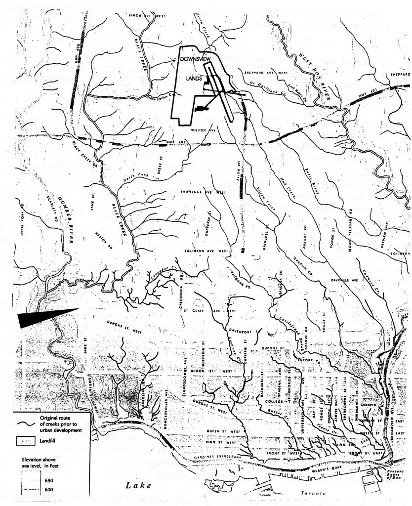
Location: The Vaughan Road/Dufferin Street area south of Eglinton Avenue and west therefrom. The creek drained an area roughly 200 acres in extent (see attached map).
Current Use: The area is used for industry, business, and housing, with roads criss-crossing most of it.
Historical Description: A tributary of Black Creek, Rountree Creek was named for the Rountree family, through whose farmlands the creek began and flowed. It is not yet known with certainty when the name “Lavender” was assigned; its romantic overtones would have fitted the creek in its earlier states, although not later. This creek is a large system and has some of the most interesting topography of any creek in the metropolitan area. In addition, it is one of perhaps only five creeks that flow in an east-west direction unlike all others. In this instance, its flow was directed by an ancient sandbar that blocked it from flowing south. Instead it was diverted to be a tributary of Black Creek. Rountree Creek had itself ten tributaries, two of them fairly large, and was fed by many springs. At one time it followed a deep ravine, and along its banks older maps show gravel pits and brickyards. The creek had fish: trout were advertised for sale by a local farmer. Deep valleys may still be found , but the creek’s general topography is like that of a moraine – hummocky. Military maps of the past show public pumps at Vaughan and at Dufferin. Today the creek is a “piteous trickle” west of Weston Road, where it has been channelled through poverty-stricken residential areas. It has been buried at various locations at different times, and much of it is probably in combined sewers. In the only area where it appears on the surface, in the most poverty-stricken residential neighbourhood, it is badly treated. Historically, the creek had importance for the stockyards, and especially for Swift’s Canadian Company, which used it as a sewer.
The Rountree family was important in the development of the stockyards and cattle market. They owned two farms. One was at Lot 35, Concession 3 from the Bay, and contains the David Rountree Burial Ground. (Some of those buried here were reinterred at Prospect Cemetery; how many graves remain is not known.) The second farm was Lot 27, Concession A, in Etobicoke, midway between Islington and Kipling A venues on the north side of Rexdale Boulevard. The John Rountree Burial Ground is located here, but the number of interments and their current status is not known.
Relative Importance: The Rountree family was important to the region as farmers whose large land holdings were mainly developed by others. The creek, as a large and unusual system, should have continued in its initial importance, but was unfortunately treated as an open sewer. Recommendations have been passed to the Preservation Board, Heritage Toronto, and the city to the effect that streets that cross buried or lost rivers should feature distinctive paving and concrete work to mark the point of crossing. This treatment is planned where two creeks cross Yonge Street at Mount Pleasant Cemetery, but the work has not yet been carried out. Rountree Creek is an excellent candidate for such a treatment: people in the area could gain a sense of the size and flow and the catchment area. It is also recommended that walking tours in the area continue on a regular basis, following the route of the creek and noting places where the main flow is joined by tributaries. A handbook for walkers, complete with a map, could be provided for self-guided tours. Archaeological investigation to determine the precise location of the Rountree burial grounds is also a priority. At these locations, plaques might well be mounted commemorating both the creek and the family, noting also that there are burials once this has been determined.
Reference Sources and Acknowledgements: Lost Creeks Project; Toronto Field Naturalists; Ontario Genealogical Society, Toronto Branch; Elizabeth McQuillan, Rowntree [sic] Family (1988); Maps Project.
Lavender Creek.