Natural heritage area.
Details of Site Location: At the original shoreline north to Highway 2.
Boundary History: The area is large and includes both banks of the river.
Current Use of Property: Housing, with recreational areas closest to the mouth.
Historical Description: Originating near Steeles Avenue, Highland Creek has two main branches, both entirely within the boundaries of the former Township/City of Scar-borough. It drains a very large area. The west branch is east of the Scarborough Golf and Country Club, and the east branch is south of Highway 401 and east of Markham Road down to Lawrence. The name given by the Mississauga Indians to the creek is Yat-qui-ee-be-no-nick, which means the first creek below the high land; hence the name for the creek and the area is based upon the topography. The creek flows through the highlands of Scarborough in a wide and very deep ravine, but spreads out into flat floodplains along both sides to where it empties into the lake. In part, these plains were heavily forested with pines. The marshlands that extended from the mouth northward were extensive and, at one time, were the habitat of much wildlife, including malaria-carrying mosquitoes. In 1830, the depth of the creek’s waters was known to have permitted the passage of 95-ton schooners up to a mile north of the mouth – an original feature of a number of Toronto’s creeks. In 1847, William Helliwell purchased 60 acres on Highland Creek, a portion of the property his father had bought there in 1818. He built two mills, the first in 1847 along with a house. His sawn lumber was floated down the creek to Cornell’s Landing, closer to the mouth, where it was loaded onto ships. In 1850, Highland Creek had 23 sawmills operating, all producing planks for railway and road-building and potash production. The sawmills were failing by 1861 owing to clear‑cutting, and rotting wood and sawdust destroyed the fish spawning areas. The forests were rapidly depleted. For a time, Cornell’s Landing continued to ship out loads of agricultural produce: potatoes, apples, wheat, and flour. Ships brought in cargoes of flour, salt, and lime. An ancient Indian trail up the east bank of the creek was used as a road for a while. A commercial fishery ran out of Highland Creek until fish stocks disappeared. Ship access to the creek and Cornell’s Landing was blocked when the Grand Trunk Railway was built, as support for its bridge required the river mouth to be greatly narrowed with infilling of the banks. As a result, the marshes upstream spread. As with most of the region’s watercourses, there had been spring floods; but once the forests were gone, the floods became extremely serious. The business acumen of William Helliwell allowed him to dominate the Highland Creek region, and he built many more structures upriver, plus a second mill, a second house, a hotel, a cooperage, and a harness and boot shop. Because of him, the history of Port Union and Highland Creek are intertwined. Helliwell was the first to collect the history of his area, and thus the first to record Scarborough’s history in any detail. After his time and the coming of the railroad, changes to the Lower Creek continued. Recreational areas necessitated further alteration of the marshes and flats. There were also changes brought about by increasingly severe flooding.
Relative Importance: The importance of the Highland Creek is as a natural heritage resource, and the Lower Creek’s potential for reclamation. The historic importance of the area is linked, in human terms, to the history of Port Union, West Hill, and the West Rouge. At one time, the region west of the Rouge was in Pickering Township as far west as the Port Union Road, but it is now within the boundaries of the City of Toronto. The Rouge and Highland Creek have more natural heritage left than all of the other Toronto-area rivers and creeks combined. The Lower Highland Creek will remain, in its greatly altered state, an important natural heritage resource if remediation can be carried out sensitively and if human interference can be controlled.
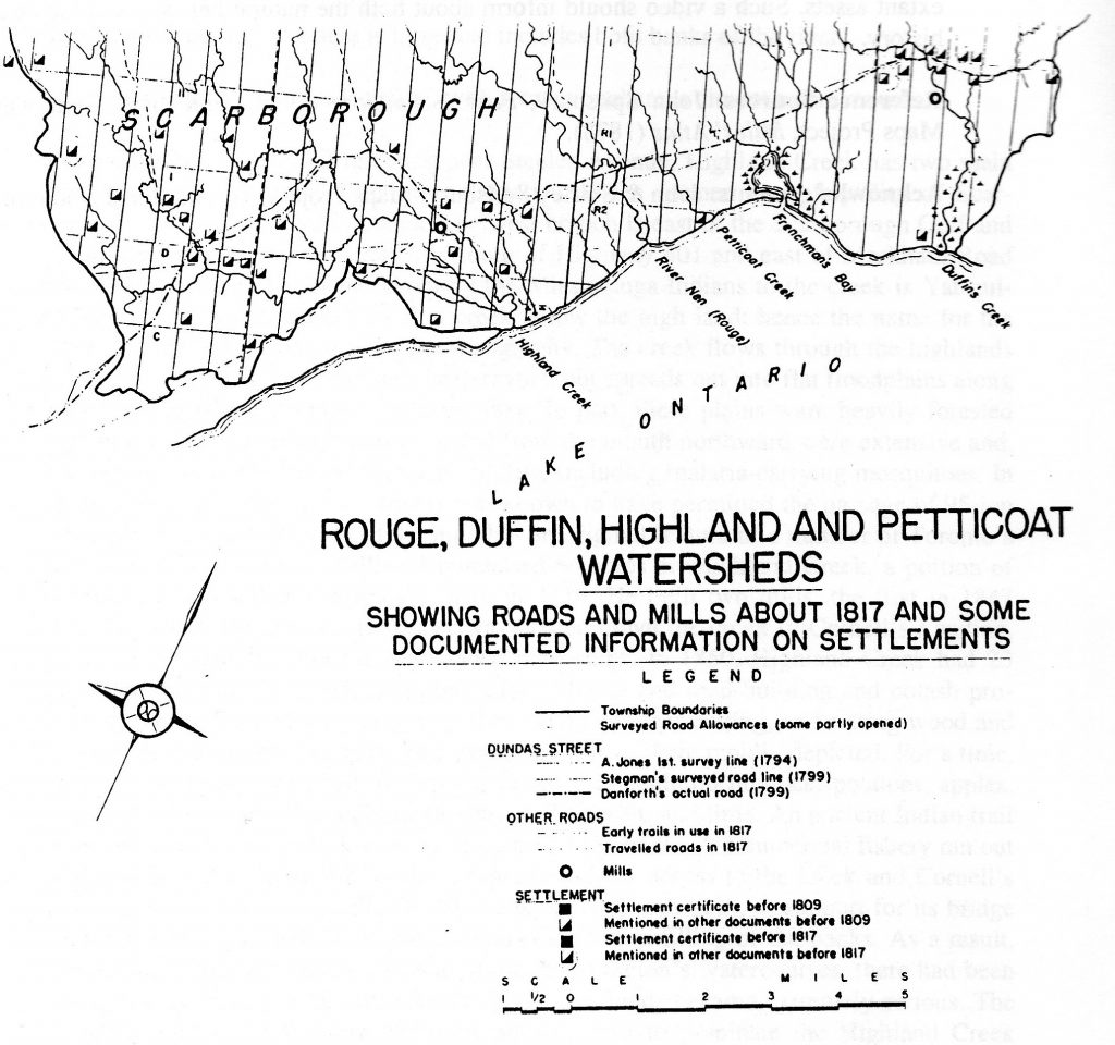
Settlement patterns in the lower Highland Creek and Rouge River valleys, c 1861. (Ontario Department of Planning and Development, Rouge Duffin Highland Petticoat Conservation Report) [4/22/2020 Note: This map depicts settlement patterns from 1817 rather than 1861.]
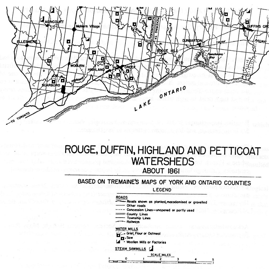
Settlement patterns in the lower Highland Creek and Rouge River valleys, c 1861. (Ontario Department of Planning and Development, Rouge Duffin Highland Petticoat Conservation Report)